

Area Guide
Hikes & Walks
From mild walks to mountain treks:
Hiking near Mount Baker
& Bellingham
Whether you've never hiked a day in your life or you live for a long day in the mountains, there's something here for you.
The Mount Baker area has trails ranging from flat lakeside walks you can knock out in under 30 minutes to full or multi-day trails through alpine lakes and meadows. In Bellingham, trails range from flat waterfront walks along the bay to forested climbs with views of the Salish Sea and the San Juan Islands.
You don't need to be experienced or in peak physical shape to have an incredible time out here. You just need to be prepared and pack the right gear to stay safe in the wilderness.
Two hikers in love — with each other and these mountains — made this guide and packed it with everything you need to know before you hit the trail. Keep scrolling or jump ahead for hiking prep tips and trail recommendations.

A view of Mount Baker along the Lake Ann trail.
Before you hit the trail
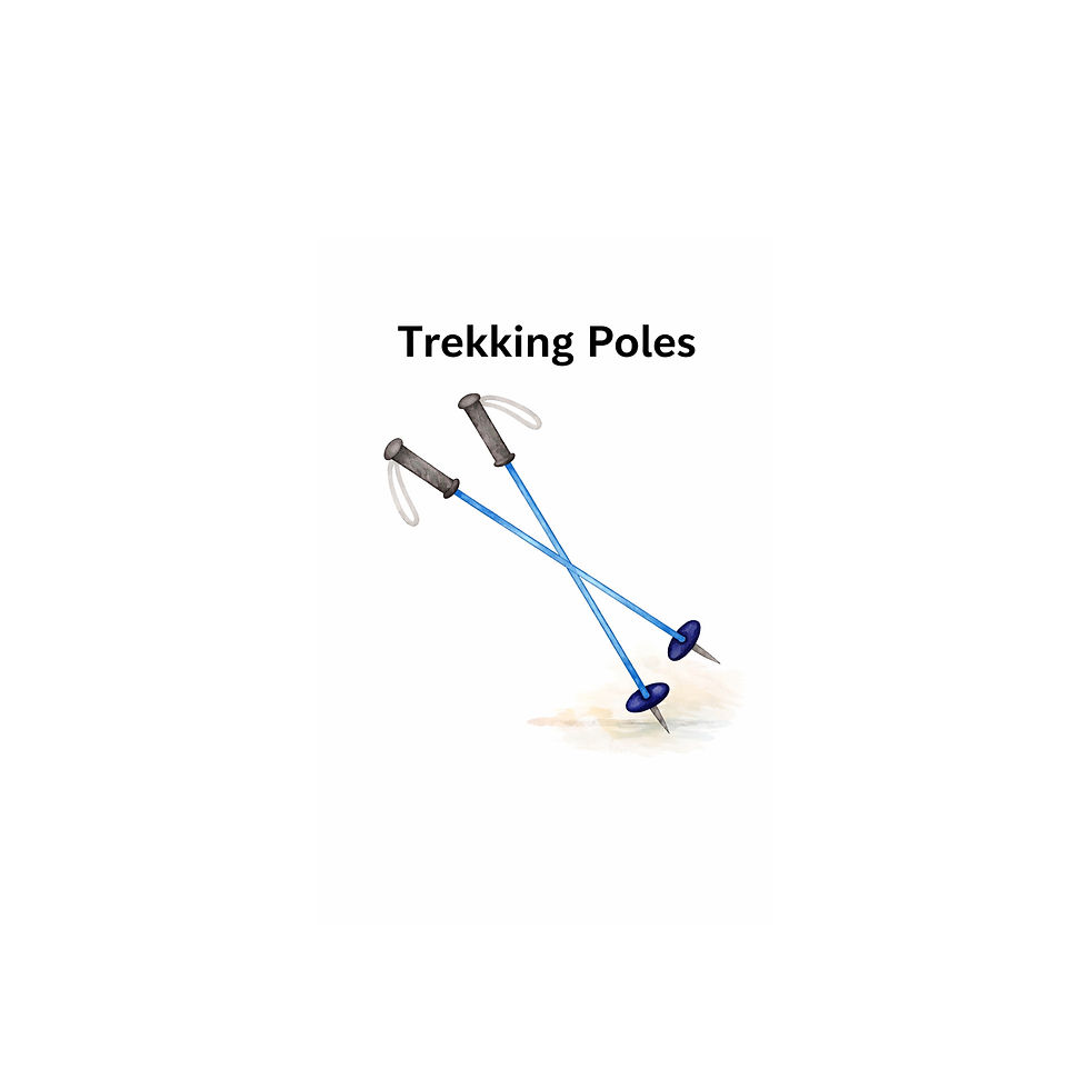
Pack the 10 Essentials
Planning a hike in the Mount Baker area? Pack the "10 Essentials," a checklist of gear that hiking and outdoor organizations worldwide recommend you carry any time you head out on a trail — even a short one. The list was originally put together in the 1930s by The Mountaineers, a Seattle-based climbing organization, and is now recognized by the U.S. National Park Service.
The idea isn't that you'll need to use all of it on every trip — most of the time you won't. It's that if something goes wrong out there, you'll have what you need to stay safe and handle the unexpected. Think of it like a seatbelt: you hope you never need it, but you'll be glad it's there.
1.) Navigation
2.) Headlamp (with batteries)
3.) Sun Protection
4.) First Aid Kit
5.) Knife
Peek inside their packs
Want a look at what Taylor and Pat typically bring along for a full day of hiking in the backcountry? Click through the gallery below.
This is just a guide, as their backpack contents vary from hike to hike based on expected weather conditions, hike complexity and duration.
6.) Fire starter
7.) Emergency shelter
8.) Extra Food
9.) Extra Water
10.) Extra Clothes


Do your homework
PARK PASSES: Most of the featured trails in the Mount Baker area require a Northwest Forest Pass to park at the trailhead. A day pass is $5; an annual pass is $30. You can buy one online, at the Glacier Public Service Center, the Heather Meadows area (automated fee station), the Mt Baker Visitor Center or at most outdoor retailers in Washington, such as REI or Dick's Sporting Goods. The America the Beautiful Pass, Senior Pass, and Access Pass are also accepted in place of a Northwest Forest Pass.


HELPFUL SITES: The Washington Trails Association (WTA) is the first place locals go before hitting the trail. The nonprofit maintains a free, up-to-date hiking guide for trails across the state — including current conditions, driving directions, trail instructions and recent trip reports from other hikers. You won't regret checking for alerts before you head out, as trails can sometimes become inaccessible due to road washouts, fallen trees or other weather-related events.
Since most trailheads in the Mount Baker area have little to no cell service, Pat and Taylor recommend screenshotting the trail page before leaving home. AllTrails is another great tool to ensure a successful hike. Download your trail map ahead of time to access it offline.
PARKING: In late August and early September, the trails in the Mount Baker area are very popular. Be sure to head out early or carpool when possible so you can find a parking spot.
INFORMATION CENTERS:
Mt. Baker Visitor's Center
7509 Mt. Baker Highway
Maple Falls, WA
360-599-1518
Open Daily: 10 am - 4 pm
Glacier Public Service Center
10091 Mt. Baker Highway
Glacier, WA 98244
360-599-2714
Saturdays & Sundays: 9 am - 3 pm
Closed Weekdays
Heather Meadows Visitor Center
Mile 55 Mt Baker Hwy
Deming, WA 98244
Open Mid July - September
10 am - 4 pm
If you're planning other outdoor activities during your visit, you may need a different pass:
-
Discover Pass: Required at Washington State Parks
-
National Park Pass: Required for entry to Olympic National Park, Mount Rainier National Park or North Cascades National Park
Still not sure what you need? This guide breaks it all down.
On the Trail
LEAVE NO TRACE: Pat and Taylor are so grateful you're traveling to share their favorite places with them. The couple kindly requests that you help keep them beautiful by practicing Leave No Trace principles while enjoying the outdoors. Pack out everything you pack in and leave rocks, plants and wildlife as you find them. Many of the trails in the area pass through fragile alpine meadows, where vegetation is easily damaged by foot traffic, so it's important to stay on the trail.
WILDLIFE ENCOUNTERS: Here are some great tips on what to do if you encounter wildlife on Washington trails.
Trails near Mount Baker Highway

The trails featured below are some of Taylor and Pat's favorite, and they're also some of the closest to Camp Saturna. Most are within an hour of the wedding venue.
THE ROADS: All but four of these Mount Baker area hikes are located along Mount Baker Highway, which is a paved road. To access the trailheads for Yellow Aster Butte, Winchester Mountain, Heliotrope Ridge and Nooksack Falls, you'll need to drive down an unpaved forest road off the highway.
Difficulty Level (as calculated by the Washington Trails Association):
MILD: Horseshoe Bend, Nooksack Falls, Picture Lake, Fire & Ice, Bagley Lakes, Artist Ridge
MODERATE: Winchester Mountain, Chain Lakes Loop, Heliotrope Ridge, Table Mountain, Ptarmigan Ridge
STRENUOUS: Yellow Aster Butte, Lake Ann
Horseshoe Bend Trail (MILD)
Length: 2.4 miles, roundtrip
Elevation Gain: 220 feet
Pass: Northwest Forest Pass
To Chair 9 Pizza & Sports Bar: 0.7 Miles
To Maple Fuels: 9.6 Miles


This is a lovely, forested walk on a well-maintained trail along the Nooksack River, and it's easy enough for the whole family. The trailhead is conveniently located in the town of Glacier.
Why she loves it
"It’s close to town and not a big time commitment. You can walk the whole trail or just down to the river for a bit.”


Why he loves it
“I love the Nooksack River and how clean and crisp the water is. It's easy to access, and we've seen salmon spawning here a couple times.
Heliotrope Ridge Trail (MODERATE)
Length: 5.5 miles, roundtrip
Pass: Northwest Forest Pass
Elevation Gain: 1,400 feet
To Chair 9 Pizza & Sports Bar: 8.4 Miles
To Maple Fuels: 16.7 Miles
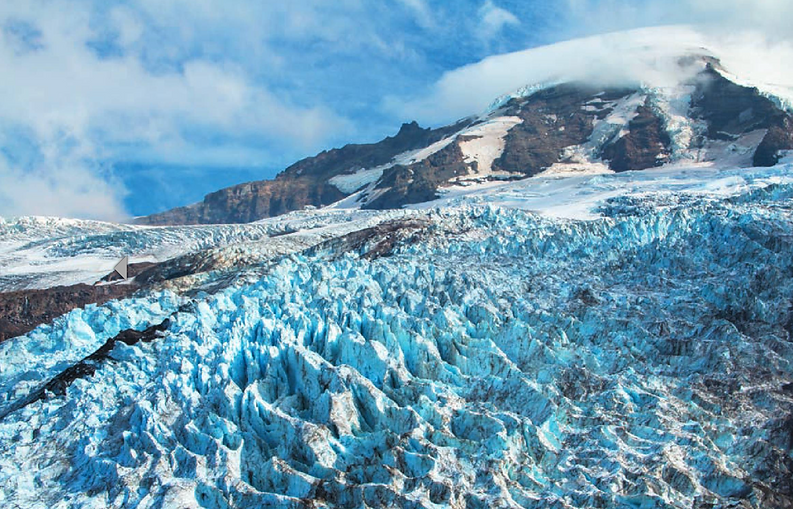
The payoff at the end of Heliotrope Ridge is a stunning closeup view of the Coleman Glacier. While the elevation gain is gradual, you'll have to navigate a few stream crossings that deserve some respect. Depending on snowmelt, recent rain and even the time of day, those streams can go from a casual wade in the morning to a fast-moving current by afternoon.
Nooksack Falls (MILD)
Length: 0.1 Miles
Elevation Gain: 14 feet
Pass: None
To Chair 9 Pizza & Sports Bar: 6.6 Miles
To Maple Fuels: 15.5 Miles


Nooksack Falls is just a short drive down a forest road off Mount Baker Highway in Glacier. A brief path leads from the parking lot to a fenced observation area overlooking the waterfall.
Why she loves it
“It’s perfect for a quick scenic stop on the way to or from a hike. It always looks different based on the season and rainfall.”
Why he loves it
"If you're into waterfalls, it's the biggest one around. Not a place you should plan on spending a ton of time at, but good for a quick stop to snap some photos."
Yellow Aster Butte (STRENUOUS)
Length: 7.5 miles, roundtrip
Elevation Gain: 2,550 feet
Pass: Northwest Forest Pass


Yellow Aster Butte is Taylor's favorite hike. The couple has enjoyed it both as a day hike and as an overnight backpacking trip. It's a strenuous trek so be sure to get an early start and be prepared for a full day of hiking. No technical experience required! The 4.5-mile forest road to the trailhead is unpaved, narrow and can have potholes or rough spots.
Why she loves it
"Once you get past the first 1.5 miles of switchbacks through the forest, the trail opens up with incredible mountain views the rest of the way.
Why he loves it
"The last half mile up the butte is a burner, but it's so worth it. There are 360 degree panoramic views with mountains on all sides. You can't help but smile when you're up there."
Winchester Mountain Lookout (MODERATE)
Length: 3.4 miles, roundtrip
Elevation Gain: 1,300 feet
Pass: Northwest Forest Pass


Winchester Mountain is Pat's favorite hike. The trail up the mountain is less than two miles long and only 1300 feet of elevation gain, with access to a lookout at 6500 feet with spectacular 360 degree views. But with all good things, there is a catch: The road. You MUST have a high clearance vehicle to access this hike, and four-wheel drive is helpful.
Why she loves it
"Once you're on the trail, it's easy to forget you just drove up the sketchiest road of your life. I appreciate how there's such a big pay off on a trail this short."
Why he loves it
"I got to say up front that the road is gnarly so make sure you've got the right car. But once you get up to the top of the mountain, it's worth it. You're literally standing into layers of snow-capped mountains on all sides, you'll be able to barely see your car in the parking lot. And since you're putting in the toughest miles driving the road, the hike itself isn't bad."
Picture Lake (MILD)
Length: 0.6 miles, roundtrip
Elevation Gain: 45 feet
Pass: Northwest Forest Pass
To Chair 9 Pizza & Sports Bar: ~ 20 miles
To Maple Fuels: ~ 29 miles

This is one of the most photographed vistas in America. Located in the Heather Meadows Area, about 33 miles from Camp Saturna, Picture Lake features a backdrop of Mount Shuksan with wildflowers in the foreground. You can follow a short, paved ADA accessible path around the lake and read interpretive signs.
Why she loves it
“Well, there’s nothing quite like seeing the reflection of craggy Mount Shuksan at sunrise. This trail is accessible to all."
Why he loves it
"If you don't do any hikes, you got to at least make sure you drive up to check out this view. It was definitely a 'welcome to the PNW' moment for me when I first visited. Mount Shuksan is criminally underrated!"
Fire and Ice (MILD)
Length: 0.5 miles, roundtrip
Elevation Gain: 100 feet
Pass: Northwest Forest Pass
To Chair 9 Pizza & Sports Bar: ~ 22 Miles
To Maple Fuels: ~ 32 miles


The Fire and Ice trail is an easy, family-friendly half-mile loop in the Heather Meadows area. It's an interpretive trail, dotted with signs that tell the story of how glaciers and volcanoes shaped this impressive place.
Bagley Lakes (MILD)
Length: 2 miles, roundtrip
Elevation Gain: 150 feet
Pass: Northwest Forest Pass
To Chair 9 Pizza & Sports Bar: ~ 23 miles
To Maple Fuels: ~ 33 miles

This is a mild hike around two alpine lakes in the Heather Meadows area. It can be done as a loop or as an out and back trail.
Lake Ann (STRENUOUS)
Length: 8.2 miles, roundtrip
Elevation Gain: 2,150 feet
Pass: Northwest Forest Pass
To Chair 9 Pizza & Sports Bar: ~23 miles
To Maple Fuels: ~ 34 miles


Taylor and Pat absolutely love this trail, which is located in the Heather Meadows area. They've done it both as a day hike and as a one-night backpacking trip. It is a burner, but no technical skills are required.
Why she loves it
"This hike gets up close and personal to the west face of my favorite mountain, Mount Shuksan."
Why he loves it
"Lake Ann is so awesome. It's a true alpine lake (yes, you can swim in it, which I highly recommend). It's so close to Mount Shuksan that you can see the waterfalls coming off the mountain. We've backpacked here a few times. One of my favorite spots in the state!"
Lake Ann
Length: 8.2 miles, roundtrip
Elevation Gain: 2150 feet
Pass: Northwest Forest Pass
To Chair 9 Pizza & Sports Bar:
To Maple Fuels:
Artist Ridge (MILD)
Length: 1.2 miles, roundtrip
Elevation Gain: 200 feet
Pass: Northwest Forest Pass
To Chair 9 Pizza & Sports Bar: ~ 24 miles
To Maple Fuels: ~ 34 miles
Taylor and Pat absolutely love this trail, which is located in the Heather Meadows area. They've done it both a day hike and as a one-night backpacking trip. It is a burner, but no technical skills are required.


Why she loves it
"This hike gets up close and personal to the west face of my favorite mountain, Mount Shuksan."
Why he loves it
"There's nothing like taking a dip in Lake Ann. You can see waterfalls off of Mount Shuksan and watch climbers make their way to the Curtis Glacier."
This is a spectacular and mild trail in the Heather Meadows area. The trail begins right next to the Artist Point parking lot at the end of Mount Baker Highway. You'll see panoramic views of Mount Shuksan and Mount Baker. There really are no dull views on this hike, and the parking lot views alone are breathtaking.
Why she loves it
"This trail is accessible for less than three months of the year, and I can never get enough of it. Not only is it a great walk, but there are great spots along the trail to drop a blanket and relax for a couple hours."
Why he loves it
"I view this as more of a place to hang out than a trail. You don't need to walk the whole thing and honestly, I'm not even sure where the trails end. Just walk around at your own pace and check out the incredible views. Oh, and this is the most beautiful parking lot you will ever see!"
Table Mountain (MODERATE)
Length: 2.6 miles, roundtrip
Elevation Gain: 725 feet
Pass: Northwest Forest Pass
To Chair 9 Pizza & Sports Bar: ~ 24 miles
To Maple Fuels: ~ 34 miles

Table Mountain is a short, but steep trail that begins at the northwest corner of the Artist Point parking lot.
Chain Lakes Loop (MODERATE)
Length: 6.5 miles, roundtrip
Elevation Gain: 1,820 feet
Pass: Northwest Forest Pass
To Chair 9 Pizza & Sports Bar: ~ 24 miles
To Maple Fuels: ~ 34 miles


This loop hike is located in the Heather Meadows area, and it's accessible from three separate parking lots. Taylor and Pat have enjoyed this moderate trek as both a day hike and an overnight backpacking trip. It features a variety of gorgeous alpine lakes, wildflower meadows and views of Mount Baker, Mount Shuksan and the North Cascades.
Why she loves it
"Love that this is a loop. You never see the same thing twice!"
Why he loves it
"If you love the mountain / lake combo like me, this is the hike for you. And the whole hike has incredible views, too."
Ptarmigan Ridge (MODERATE)
Length: 9 miles, roundtrip
Elevation Gain: 1,800 feet
Pass: Northwest Forest Pass
To Chair 9 Pizza & Sports Bar: ~ 24 miles
To Maple Fuels: ~ 34 miles

You can day hike or backpack this hike to get stunningly close to the east side of Mount Baker. The trail, located in the Heather Meadows area, begins on the Chain Lakes trail from the northwest corner of the parking lot at Artist Point.
Trails and parks near Bellingham
Boulevard Park is a scenic waterfront park in Bellingham. You can take a walk along Bellingham Bay, relax at one of the park's beaches or connect to South Bay trail, which also passes through this park.
To Camp Saturna: 45 Miles


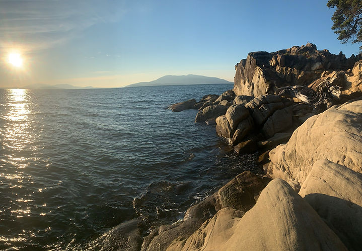
Oyster Dome is an iconic coastal hike in Bellingham. After a forested climb up Blanchard Mountain, you're rewarded with sweeping views of the Salish Sea and the San Juan Islands at the top. It's also a great spot to watch paragliders.
This is an urban park along the water, featuring trails, a dog park and the longest public pier in Washington state.
Pass: None

Whatcom Falls Park is a popular city park just ten minutes from downtown Bellingham, with miles of forested trails along Whatcom Creek. You can easily reach the waterfall via a short walk from the parking lot. It's accessible for all ages and abilities.
Larrabee State Park
To Camp Saturna: 40 Miles
Pass: Discover Pass
Larrabee State Park is Washington's first state park. It's known for its postcard views of Samish Bay and the San Juan Islands. You'll find 18 miles of trails to explore in this park + beach access.
Other Trails Around Washington
Exploring another part of Washington state during your trip?
Here are some additional trails that Taylor and Pat have enjoyed together in the Evergreen state. Only pursue these options if you're planning to extend your stay, as most of these trails are hours away from the wedding venue.
NORTH CASCADES NATIONAL PARK
Maple Pass Loop (moderate/hard)
MOUNT RAINIER NATIONAL PARK
Burroughs Mountain (hard)
Fremont Lookout (moderate)
Myrtle Falls (easy)
Skyline Trail Loop (moderate)
OLYMPIC PENINSULA
Cape Flattery (easy)
Mount Ellinor (hard)
Mount Townsend (hard)
Hurricane Ridge (easy to hard)
Ruby Beach (easy)
Mount Storm King (moderate/hard)
WHIDBEY ISLAND
Deception Pass State Park (easy / moderate)
Ebey's Landing (easy / moderate)
ORCAS ISLAND
Mount Constitution (drive or hike)
Turtleback Mountain (moderate)
LEAVENWORTH
Colchuck Lake (moderate/hard)
SNOQUALMIE / NORTH BEND REGION
Rattlesnake Ledge (moderate)
Snoqualmie Falls (easy)
SEATTLE AREA
Lincoln Park (easy)
Discovery Park (easy)
VANCOUVER, B.C.
Stanley Park (easy)
CHILLIWACK, B.C.
Chilliwack Lake (easy)